![](/images/other/stat-length.png)
![Excursión A pie Villeneuve (VD) - Les Grangettes - Photo](https://media.geolcdn.com/t/1900/400/ext.pjpeg?maxdim=2&url=https%3A%2F%2Fstatic1.geolcdn.com%2Fsiteimages%2Fupload%2Ffiles%2F1545311037marcheuse_200dpi.jpg)
Les Grangettes
famiski
Usuario
![Longitud](/images/other/stat-length.png)
Longitud
8,2 km
![Altitud máxima](https://static1.geolcdn.com/siteimages/upload/files/1508320355ic_sort_altitude_max_24dp.png)
Altitud máxima
385 m
![Desnivel positivo](https://static1.geolcdn.com/siteimages/upload/files/1508320355ic_sort_den_pos_24dp.png)
Desnivel positivo
56 m
![Km-Effort](/images/other/stat-length.png)
Km-Effort
9 km
![Altitud mínima](https://static1.geolcdn.com/siteimages/upload/files/1508320355ic_sort_altitude_min_24dp.png)
Altitud mínima
371 m
![Desnivel negativo](https://static1.geolcdn.com/siteimages/upload/files/1508320355ic_sort_den_neg_24dp.png)
Desnivel negativo
57 m
![Boucle](https://static1.geolcdn.com/siteimages/upload/files/16400158638029165_repeat_loop_refresh_sync_direction_icon.png)
Boucle
Sí
Fecha de creación :
2023-03-24 09:36:53.36
Última modificación :
2023-03-24 09:37:12.342
![A pie](https://static1.geolcdn.com/sitytour/trail-icons/100.png)
2h02
Dificultad : Fácil
![Escanee este código QR para abrir la excursión en la aplicación SityTrail](https://capi.geolives.com/qq0zvz2zws4bq2lad0pu/sitytour/trails/3595792/qr.png?size=200)
Aplicación GPS de excursión GRATIS
A propósito
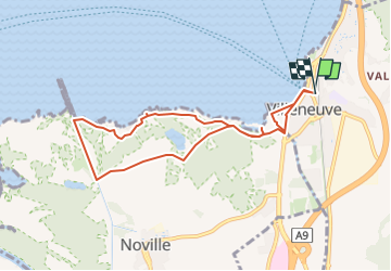
Ruta A pie de 8,2 km a descubrir en Valdia, District d'Aigle, Villeneuve (VD). Esta ruta ha sido propuesta por famiski.
Descripción
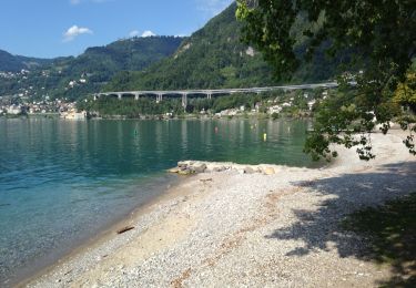
La promenade commence à gare de Villeneuve pour ensuite longer le lac en direction de la réserve naturelle des Grangettes. Vous traverserez le magnifique jardin instinctif et profiterez d'une splendide vue sur le lac Léman.
Localización
País:
Switzerland
Región :
Valdia
Departamento/provincia :
District d'Aigle
Municipio :
Villeneuve (VD)
Localidad:
Unknown
Salida:(Dec)
Salida:(UTM)
340598 ; 5140391 (32T) N.
Comentarios
Excursiones cerca
![Excursión Senderismo Montreux - Montreux - Villeneuve - Le Bouveret - Photo](https://media.geolcdn.com/t/375/260/ext.jpg?maxdim=2&url=https%3A%2F%2Fstatic1.geolcdn.com%2Fsiteimages%2Fupload%2Ffiles%2F1553511878bg_sport_marche.png)
![Senderismo Senderismo](https://static1.geolcdn.com/sitytour/trail-icons/101.png)
Montreux - Villeneuve - Le Bouveret
Senderismo
Muy fácil
(1)
Montreux,
Valdia,
District de la Riviera-Pays-d’Enhaut,
Switzerland
![](/images/other/stat-length.png)
14,5 km | 16,4 km-effort
Desconocido
![](https://static1.geolcdn.com/siteimages/upload/files/16400158638029165_repeat_loop_refresh_sync_direction_icon.png)
No
![Excursión Senderismo Villeneuve (VD) - Bois de Chillon - Photo](https://media.geolcdn.com/t/375/260/ext.jpg?maxdim=2&url=https%3A%2F%2Fservices.sitytrail.com%2FGeolivesWS%2FDownloadMedia.ashx%3FTrailID%3D470065%26Media%3D20150908161735.jpg)
![Senderismo Senderismo](https://static1.geolcdn.com/sitytour/trail-icons/101.png)
Bois de Chillon
Senderismo
Fácil
Villeneuve (VD),
Valdia,
District d'Aigle,
Switzerland
![](/images/other/stat-length.png)
10,6 km | 16,1 km-effort
2h 30min
![](https://static1.geolcdn.com/siteimages/upload/files/16400158638029165_repeat_loop_refresh_sync_direction_icon.png)
Sí
![Excursión Bicicleta Villeneuve (VD) - Coteaux du Chablais - Berge du Rhõne - Photo](https://media.geolcdn.com/t/375/260/ext.jpg?maxdim=2&url=https%3A%2F%2Fservices.sitytrail.com%2FGeolivesWS%2FDownloadMedia.ashx%3FTrailID%3D461969%26Media%3D20150821110429.jpg)
![Bicicleta Bicicleta](https://static1.geolcdn.com/sitytour/trail-icons/200.png)
Coteaux du Chablais - Berge du Rhõne
Bicicleta
Medio
Villeneuve (VD),
Valdia,
District d'Aigle,
Switzerland
![](/images/other/stat-length.png)
50 km | 59 km-effort
2h 24min
![](https://static1.geolcdn.com/siteimages/upload/files/16400158638029165_repeat_loop_refresh_sync_direction_icon.png)
No
![Excursión Senderismo Roche (VD) - Boucle d Arvel Joux Verte - Photo](https://media.geolcdn.com/t/375/260/ext.jpg?maxdim=2&url=https%3A%2F%2Fservices.sitytrail.com%2FGeolivesWS%2FDownloadMedia.ashx%3FTrailID%3D264798%26Media%3Dfix__20140409134802.jpg)
![Senderismo Senderismo](https://static1.geolcdn.com/sitytour/trail-icons/101.png)
Boucle d Arvel Joux Verte
Senderismo
Medio
Roche (VD),
Valdia,
District d'Aigle,
Switzerland
![](/images/other/stat-length.png)
6,9 km | 18,7 km-effort
1h 44min
![](https://static1.geolcdn.com/siteimages/upload/files/16400158638029165_repeat_loop_refresh_sync_direction_icon.png)
Sí
![Excursión Senderismo Veytaux - st_Rochers-de-Naye - Photo](https://media.geolcdn.com/t/375/260/ext.jpg?maxdim=2&url=https%3A%2F%2Fstatic1.geolcdn.com%2Fsiteimages%2Fupload%2Ffiles%2F1553511878bg_sport_marche.png)
![Senderismo Senderismo](https://static1.geolcdn.com/sitytour/trail-icons/101.png)
st_Rochers-de-Naye
Senderismo
Muy fácil
Veytaux,
Valdia,
District de la Riviera-Pays-d’Enhaut,
Switzerland
![](/images/other/stat-length.png)
6,4 km | 11,1 km-effort
1h 42min
![](https://static1.geolcdn.com/siteimages/upload/files/16400158638029165_repeat_loop_refresh_sync_direction_icon.png)
No
![Excursión Senderismo Montreux - Dent de Jaman - Rochers - de Naye - Photo](https://media.geolcdn.com/t/375/260/ext.jpg?maxdim=2&url=https%3A%2F%2Fstatic1.geolcdn.com%2Fsiteimages%2Fupload%2Ffiles%2F1553511878bg_sport_marche.png)
![Senderismo Senderismo](https://static1.geolcdn.com/sitytour/trail-icons/101.png)
Dent de Jaman - Rochers - de Naye
Senderismo
Muy fácil
(1)
Montreux,
Valdia,
District de la Riviera-Pays-d’Enhaut,
Switzerland
![](/images/other/stat-length.png)
3,4 km | 6,6 km-effort
Desconocido
![](https://static1.geolcdn.com/siteimages/upload/files/16400158638029165_repeat_loop_refresh_sync_direction_icon.png)
No
![Excursión Senderismo Montreux - Rando Caux Jaman Nayes - Photo](https://media.geolcdn.com/t/375/260/ext.jpg?maxdim=2&url=https%3A%2F%2Fstatic1.geolcdn.com%2Fsiteimages%2Fupload%2Ffiles%2F1553511878bg_sport_marche.png)
![Senderismo Senderismo](https://static1.geolcdn.com/sitytour/trail-icons/101.png)
Rando Caux Jaman Nayes
Senderismo
Difícil
Montreux,
Valdia,
District de la Riviera-Pays-d’Enhaut,
Switzerland
![](/images/other/stat-length.png)
15,8 km | 29 km-effort
4h 17min
![](https://static1.geolcdn.com/siteimages/upload/files/16400158638029165_repeat_loop_refresh_sync_direction_icon.png)
Sí
![Excursión A pie Montreux - Les Gorges du Chauderon - Photo](https://media.geolcdn.com/t/375/260/ext.jpg?maxdim=2&url=https%3A%2F%2Fstatic1.geolcdn.com%2Fsiteimages%2Fupload%2Ffiles%2F1545311037marcheuse_200dpi.jpg)
![A pie A pie](https://static1.geolcdn.com/sitytour/trail-icons/100.png)
Les Gorges du Chauderon
A pie
Fácil
Montreux,
Valdia,
District de la Riviera-Pays-d’Enhaut,
Switzerland
![](/images/other/stat-length.png)
6,7 km | 11,8 km-effort
2h 40min
![](https://static1.geolcdn.com/siteimages/upload/files/16400158638029165_repeat_loop_refresh_sync_direction_icon.png)
Sí
![Excursión A pie Montreux - Itinéraire course à pied : Boucle Hauts-de-Caux - Sonchaux - Photo](https://media.geolcdn.com/t/375/260/ext.jpg?maxdim=2&url=https%3A%2F%2Fstatic1.geolcdn.com%2Fsiteimages%2Fupload%2Ffiles%2F1545311037marcheuse_200dpi.jpg)
![A pie A pie](https://static1.geolcdn.com/sitytour/trail-icons/100.png)
Itinéraire course à pied : Boucle Hauts-de-Caux - Sonchaux
A pie
Fácil
Montreux,
Valdia,
District de la Riviera-Pays-d’Enhaut,
Switzerland
![](/images/other/stat-length.png)
9,8 km | 15,4 km-effort
3h 30min
![](https://static1.geolcdn.com/siteimages/upload/files/16400158638029165_repeat_loop_refresh_sync_direction_icon.png)
Sí